Business Details
Expert Land Surveying Services in Portland, OR
Established in the Portland metropolitan area, our firm specializes in precise land boundary determination and surveying solutions. Led by Andrew M. Miller, a licensed Professional Land Surveyor (PLS) with decades of hands-on experience, we deliver accurate, legally compliant services tailored to residential and commercial needs. Our expertise includes boundary surveys, property line adjustments, and legal description writing, ensuring clients receive comprehensive documentation and on-site markings. We prioritize direct client communication, addressing individual requirements while maintaining strict adherence to state regulations.Our commitment to quality is reflected in peer endorsements from seasoned professionals, underscoring our technical proficiency and ethical standards. By combining meticulous fieldwork with detailed record-keeping, we provide enduring value through permanent public survey records. Available Monday through Saturday, we accommodate client schedules while maintaining rigorous attention to detail in every project.

Services
Boundary Survey
Boundary Marking
Property Line Adjustment
Legal Description Writing
Record of Survey Map
Neighbor Encroachment Survey
Timber Boundary Marking
Fencing Survey
House Addition Survey
Home Purchase Survey
Highlights and features
- We guarantee a licensed Professional Land Surveyor performs all work
- Our surveys include permanent public record documentation for legal security
- We offer Saturday appointments to accommodate client schedules
- Endorsed by peers with 37+ years of industry experience
- Direct client communication ensures clear understanding of project needs
What people say
Timely, accurate services
Proven expertise
Competent professional
Clear communication
Legal compliance
Services
Boundary Survey
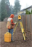
A comprehensive investigation to determine property corners and lines through deed research and on-site measurements. Our process combines historical records with physical evidence to establish accurate boundaries. Licensed surveyors mark locations and prepare documentation for legal recognition.
Property Line Adjustment
Modifies existing property lines through legal procedures requiring neighbor agreement and municipal approval. We conduct preliminary surveys to ensure compliance with zoning codes and prepare official maps for recording. Involves coordination with title companies and legal professionals.
Legal Description Writing
Creates precise textual representations of property boundaries for legal transactions. Descriptions use standardized terminology to define parcel locations and dimensions. Documents become permanent public records when recorded with county offices, ensuring clarity for future ownership transfers.
Record of Survey Map
Provides detailed graphical representation of surveyed boundaries with measurements to nearby features. Maps include survey methodology narratives and professional conclusions. Required for permanent marker installation, these documents serve as reference points for future land transactions and disputes.
Neighbor Encroachment Survey
Identifies unauthorized structures or improvements crossing property lines through precise measurements. Our surveys document physical evidence and historical records to resolve disputes. Results provide legal basis for negotiations or corrective actions regarding fences, buildings, or landscaping.
People
Andrew M. Miller
Owner / Licensed Land Surveyor
Andrew M. Miller is a licensed Professional Land Surveyor with extensive experience providing accurate and reliable surveying services in the Portland area. His expertise includes boundary determination, legal documentation, and client-focused problem solving.
Questions
What does a boundary survey include?
Our boundary surveys combine deed research with on-site measurements to locate property corners and lines. We mark boundaries physically and prepare official maps for county recording.
How can I adjust my property line?
Property line adjustments require neighbor agreement and municipal approval. We'll conduct preliminary surveys to ensure code compliance and prepare legal documents for official recording.
Do you provide legal descriptions?
Yes, we create legally binding property descriptions using standardized terminology. These documents become permanent public records when filed with county offices.
What areas do you serve?
We primarily serve Portland, Oregon and surrounding areas including Wilsonville. Contact us for specific location details.
Are your surveys legally recognized?
All surveys meet state licensing requirements and produce official records. Our work is conducted by a licensed Professional Land Surveyor and filed with county authorities.
Can you help with neighbor boundary disputes?
Yes, we perform encroachment surveys to document unauthorized structures crossing property lines. Our findings provide factual basis for resolving disputes through legal channels.