Business Details
43 Years
experience
Expert Land Surveying Services in Vancouver, WA
Since 1983, Minister & Glaeser Surveying has been a trusted provider of high-quality surveying and mapping services, delivering precision and reliability across diverse projects. Our team of licensed professionals brings decades of combined experience in boundary, topographic, hydrographic, and construction surveys, serving clients ranging from private property owners to federal agencies. We prioritize safety, quality assurance, and client collaboration, ensuring every project meets exacting standards while adhering to schedules and budgets. Our expertise spans advanced technologies like GPS and digital terrain modeling, supported by a fleet of field crews and state-of-the-art equipment.With offices in Vancouver and Pasco, Washington, we serve the Pacific Northwest, maintaining a reputation for excellence through meticulous attention to detail and a commitment to resolving complex surveying challenges. Our principals, all Professional Land Surveyors licensed in multiple states, lead with technical proficiency and a dedication to minimizing professional liability through rigorous procedural checks. Client satisfaction remains central to our operations, evidenced by longstanding relationships and commendations for past performance on large-scale projects like light rail systems.
Services
Boundary Surveys
ALTA Surveys
Construction Staking
Topographic Mapping
Hydrographic Surveying
Legal Descriptions
FEMA Flood Certificates
Geodetic Control
Volume Calculations
Photogrammetric Mapping
Details
- Year established: 1983
Highlights and features
- We have over 30 years of experience in land surveying across the Pacific Northwest.
- Our team includes 7 licensed surveyors with expertise in federal and state projects.
- We utilize advanced GPS and digital modeling technologies for accurate results.
- Our safety-first approach ensures projects are completed on time and within budget.
- We maintain long-term client relationships through transparent communication and quality assurance.
Services
Boundary Surveys
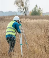
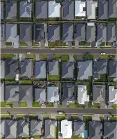
Our boundary surveys precisely define property lines using historical records and modern technology. We resolve disputes, support legal documentation, and ensure compliance with local regulations. Clients rely on our licensed surveyors to deliver accurate, legally defensible results for residential, commercial, and public projects.
Topographic Mapping
We create detailed topographic maps showing natural and man-made features for engineering and design purposes. Our surveys capture elevation data, vegetation, and structures to support infrastructure planning. Advanced tools ensure high-resolution outputs tailored to project-specific needs.
Hydrographic Surveying
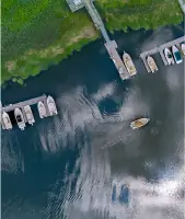
Our hydrographic surveys map underwater terrain for dredging, floodplain analysis, and environmental studies. Using sonar and GPS, we collect bathymetric data to assess water bodies and support coastal engineering. Clients benefit from precise measurements critical for regulatory compliance.
Construction Staking
We provide construction staking to guide accurate project execution, marking key points for foundations, utilities, and structures. Our services ensure alignment with design plans, minimizing errors and rework. Real-time GPS technology enhances efficiency on complex job sites.
ALTA Surveys
ALTA surveys meet national standards for commercial property transactions, identifying boundaries, easements, and improvements. Our licensed surveyors collaborate with title companies to deliver comprehensive reports, reducing legal risks for buyers and lenders.
People
Edmund Denny
Principal, Project Manager
Edmund Denny is a Professional Land Surveyor with 32 years of experience in the Pacific Northwest. Licensed in multiple states, he specializes in control surveys, boundary resolution, and construction projects, including light rail systems.
Daniel Renton
Principal, Project Manager
Daniel Renton has 20 years of surveying expertise, focusing on GPS methods and school infrastructure projects. Licensed in Washington, Oregon, and Idaho, he ensures precision in topographic and construction surveys using advanced digital tools.
David Denny
Principal, Project Manager
David Denny brings 31 years of experience in boundary surveys and legal descriptions. Licensed in Washington and Oregon, he excels in data research and quality assurance, managing field crews for complex engineering projects.
Kevin Bethje
Principal, Project Manager
Kevin Bethje has 18 years of expertise in geodetic surveys and digital modeling. Licensed in four states, he oversees topographic and construction surveys for schools, ensuring accuracy through rigorous quality control processes.
Questions
What types of surveying services do you offer?
We provide boundary, topographic, hydrographic, ALTA, and construction surveys, along with legal descriptions and FEMA flood certificates.
Are your surveyors licensed?
Yes, our principals and key personnel are Professional Land Surveyors licensed in Washington, Oregon, Idaho, California, Montana, and Arizona.
Do you work on large-scale infrastructure projects?
Yes, we’ve completed surveys for light rail systems and other major construction projects across the Pacific Northwest.
What areas do you serve?
We operate throughout Washington, Oregon, Idaho, Montana, and Arizona, with offices in Vancouver and Pasco, Washington.
How do you ensure survey accuracy?
We use GPS, digital terrain modeling, and rigorous quality checks to maintain precision in all projects.