Business Details
36 Years
experience
Professional Land Surveying Services in Colorado
Established in 1990, Clear Creek Surveying has built a reputation as a trusted leader in professional land surveying services across Colorado's mountain regions. Our team of licensed surveyors brings decades of specialized expertise in boundary surveys, subdivision plats, and complex mapping projects within Clear Creek, Gilpin, and Jefferson Counties. Utilizing advanced technology and proven methodologies, we deliver precise topographic data and legal documentation that meet the highest industry standards. Our commitment to technical excellence is matched by our dedication to client collaboration, ensuring every project receives personalized attention from initial consultation through final deliverables. With extensive experience in historic mining districts and modern development projects, we provide surveying solutions that combine historical accuracy with contemporary precision.Our services support commercial real estate transactions, municipal planning initiatives, and construction projects requiring exacting spatial data. Through consistent quality control and adherence to ALTA/NSPS standards, we maintain the trust of clients who rely on our expertise for critical land development decisions. Our local knowledge of Colorado's unique terrain and regulatory environment enables efficient project execution while maintaining strict compliance with municipal requirements. This combination of technical proficiency, regional expertise, and client-focused service has established us as the preferred surveying partner for professionals across multiple industries.

Services
Topographic Mapping
ALTA/NSPS Surveys
Land Survey Plats
Subdivision Plats
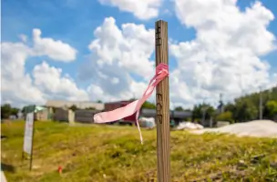
Construction Staking
Control Surveys
Annexation Maps
Condominium Mapping
Boundary Surveys
Record Drawings
Details
- Year established: 1990
Highlights and features
- We have over 25 years of experience in Colorado mountain surveying
- Our team specializes in boundary surveys and subdivision plats
- We follow ALTA/NSPS standards for commercial real estate surveys
- Our surveyors use advanced GPS and mapping technology
- We maintain detailed knowledge of local zoning regulations
Services
Topographic Mapping
Our topographic mapping service creates detailed land representations using specialized equipment. This surveying method documents elevation changes, natural features, and man-made structures to support construction planning and land development. Clients receive accurate digital and printed maps that meet engineering specifications for various projects.
ALTA/NSPS Surveys
ALTA/NSPS Land Title Surveys provide comprehensive property documentation for commercial real estate transactions. These surveys identify boundary lines, easements, and improvements while following national standards. Our team works with title companies to ensure complete property understanding before major investments.
Subdivision Plats
Subdivision platting services create legal land division documents for new developments. Our surveyors produce detailed maps showing lot boundaries, access points, and utility locations. We coordinate with local governments to ensure compliance with zoning requirements for residential and commercial projects.
Construction Staking
Construction staking services establish precise project boundaries using advanced surveying equipment. Our team marks building locations, utility routes, and elevation points to guide construction crews. This ensures structures are built according to approved plans and specifications.
Control Surveys
Control surveys establish reference points for engineering projects using GPS and total stations. These benchmarks provide accurate positioning data for large-scale developments. Our team creates durable monuments and maintains detailed records for future project phases.
Questions
What surveying services do you offer?
We provide topographic mapping, ALTA/NSPS land title surveys, subdivision plats, construction staking, and control surveys for commercial and municipal clients in Colorado's mountain regions.
Do you serve areas outside Colorado?
Our primary service area includes Clear Creek, Jefferson, and Gilpin Counties in Colorado. While we focus on mountain regions, we can discuss special projects in adjacent areas.
How long does a typical survey take?
Project duration varies based on complexity and location. Most standard surveys require 1-2 weeks from initial consultation to final deliverables, with expedited options available for urgent needs.
Are your surveyors licensed?
All our surveying professionals hold active Colorado state licenses and maintain current certifications. Our team includes experienced surveyors with decades of combined field experience.
Can you help with property boundary disputes?
We provide boundary survey services that establish legal property lines using historical records and field measurements. Our documentation can help resolve disputes through mediation or legal proceedings.
Do you work with residential clients?
While we specialize in commercial and municipal projects, we accept select residential surveys requiring specialized expertise in mountainous terrain and complex boundary situations.