Providing accurate, on-time, and cost-effective land survey services.
Zenith Land Surveying, Inc. was founded in 2004 on the principle that true service forms the bedrock of a successful business. We believe that our reputation for excellence isn't a destination but a daily journey, painstakingly built with each project we undertake. Our paramount goal is to provide our clients with land survey services that are not only accurate and timely but also delivered in a cost-effective manner.
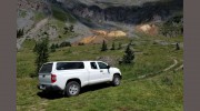
We leverage the latest technology to ensure the highest level of precision and efficiency. Our field operations utilize state-of-the-art Leica Robotic Total Stations and Carlson GPS equipment, meticulously recording data for each project. Back in our office, our skilled team employs Carlson drafting software, an AutoCAD-based platform, to create comprehensive and detailed maps and surveys. Importantly, we manage all aspects of our work in-house, allowing for seamless coordination and control over every stage of the project. Should your project require specialized services such as photogrammetric surveys, aerial surveys, lidar surveys, or title searches, we have a trusted network of professionals we can readily engage to ensure a comprehensive and efficient solution.
Our team comprises highly experienced professionals, each having earned their expertise through years of dedicated service. Many of our team members began their careers as entry-level rodmen, steadily progressing through the ranks and gaining a profound understanding of the complexities of land surveying. This "from the ground up" approach fosters a culture of commitment and technical proficiency that permeates every level of our company.
Continuing a Legacy of Excellence
Zenith Land Surveying is deeply honored to carry on the distinguished legacy of William J. Stengel, PLS 4846. Bill, a pioneer in the field of land surveying, began his career in Boulder County in 1951. He served as the Boulder County Surveyor for 14 years, from 1988 to 2002, leaving an indelible mark on the area's surveying practices. Upon Bill's retirement in 2008, he entrusted his extensive archives to Zenith Land Surveying, permitting us to continue his tradition of meticulous and reliable service.
We are proud to offer our expertise to anyone seeking information about a survey completed by Bill Stengel. Furthermore, if your property holds the history of a survey initiated by Bill and requires continuation, please don't hesitate to reach out. We are committed to upholding his legacy by providing the same level of dedication and precision that has characterized his work for generations.
Service Offerings
At Zenith Land Surveying, we offer a comprehensive suite of land surveying services, designed to meet the diverse needs of our clients:
- Land Boundary Surveys: Our primary service focus is retracement land surveying, specializing in accurately establishing property boundaries based on historical records, existing monuments, and legal analysis. We meticulously analyze boundary evidence, combining technical expertise with a deep understanding of legal precedents to create precise and reliable boundary maps.
- ALTA/NSPS Land Title Surveys: These specialized surveys are essential for real estate transactions, providing a high level of detail and certification to ensure a clear understanding of title and boundary issues. We adhere to the rigorous standards set by the American Land Title Association and the National Society of Professional Surveyors.
- Design Surveys: We provide precise surveys for construction projects, including building footprints, easements, and site grading plans. Our services ensure that construction proceeds according to approved plans, minimizing costly rework and delays.
- Topographic Surveys: These detailed surveys depict the contours and elevation of a site, providing valuable information for planning purposes, drainage analysis, and construction preparation. We utilize advanced instruments and software to generate accurate topographic maps.
- Subdivision Surveys: We handle the complex surveying needs of land development projects, creating legal subdivisions, plotting lots, and ensuring compliance with all local zoning regulations.
- Mapping: Our team creates a wide range of maps, from basic boundary maps to intricate topographic maps, utilizing industry-standard software and GIS technologies.
- Expert Analyst/Expert Witness:
Our professionals are qualified to provide expert analysis and testimony in legal disputes involving land boundaries, easements, and property rights.
- Mining Claim Surveys: We perform surveys for mining operations, accurately identifying claim boundaries, assessing mineral rights, and ensuring compliance with regulations.
- Easements Surveys: We establish and map easements, ensuring that the rights of all parties involved are clearly defined and protected.
- Flood Mapping: We provide FEMA Flood Elevation Certification services, accurately determining flood zones and heights to aid in property development and insurance requirements.
- Construction Surveying: We provide ongoing surveying support throughout the construction process, ensuring accurate placement of structures, utilities, and other infrastructure elements.

Be the first to review Zenith Land Surveying.
Write a Review