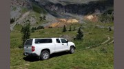
At Ehrhart Land Surveying, we believe in providing professional land surveying services with personal customer service. Our core values revolve around relationship building, and we enhance customer communication by providing status reports, document accessibility, and more. We understand the unique problems of each assignment and offer a wide range of services tailored to meet the needs of our clients throughout the Rocky Mountain region.
Our Services
We provide a variety of surveys and services to meet the diverse needs of our clients. These include:
- Boundary Surveys: We conduct thorough boundary surveys to identify and mark property lines and ensure accurate property ownership.
- ALTA Survey: Our ALTA surveys meet the standards of the American Land Title Association and the American Congress on Surveying and Mapping, providing comprehensive data for property ownership and land development.
- Land Survey Plat (LSP): We create detailed land survey plats to provide accurate and reliable information for land division, construction, and other development projects.
- Improvement Survey Plat (ISP): Our ISP surveys document the improvements made to a property, including structures, utilities, and other features.
- Legal Descriptions & Easements: We provide accurate legal descriptions and easements to ensure that property boundaries and access rights are properly documented.
- Subdivisions: Our team can assist with the creation of subdivisions, including platting and mapping of new properties.
- Design & Construction: We offer topographic surveys, site plans, construction layout, and as-built surveys to support all stages of construction projects.
- FEMA Elevation Certificate: We provide FEMA elevation certificates to help property owners understand their flood zone risk and comply with flood insurance requirements.
- FEMA Letter of Map Amendment (LOMA): If you believe your property has been incorrectly included in a high-risk flood zone, we can help you apply for a LOMA to adjust the flood map designation.
- Improvement Location Certificate (ILC): Our ILCs verify the location and elevation of structures on a property relative to the base flood elevation, providing essential information for flood insurance and risk assessment.
Our Team and Experience
Our principal land surveyor, John Ehrhart, has been surveying in the Colorado region since 1992. Our personnel are dedicated to providing practical land surveying solutions, focusing on the individual needs of each client with timeliness and accuracy. We take personal responsibility for the success of each project and maintain full insurance coverage, including errors and omissions, general liability, and worker's compensation insurance.
Our Philosophy and Values
At Ehrhart Land Surveying, we believe in maintaining the highest level of integrity, professionalism, and customer service. We prioritize relationships and strive to understand the unique needs and challenges of each client. Our commitment to excellence and dedication to our core values sets us apart from other surveying companies in the Rocky Mountain region.

Be the first to review Intergral Surveying.
Write a Review