Business Details
45 Years
experience
Expert Environmental Consulting Services in San Marcos, TX
Hays Environmental Consulting, established in San Marcos, Texas, has been delivering specialized environmental consulting services since 1981. Our expertise spans facility planning for land subdivisions, advanced septic system design, and digital cartography tailored to landowners, surveyors, civil engineers, and builders. With decades of hands-on experience in Texas geology, including cave and Karst aquifer analysis, we combine technical precision with deep environmental knowledge. Our team holds critical industry licenses, including Registered Sanitarian, Professional Geoscientist, and Site Evaluator certifications, ensuring compliance with state and federal standards. We prioritize client collaboration, offering custom solutions like smartphone-accessible topographic maps for hunters, hikers, and ranchers.Our services integrate fieldwork, LiDAR technology, and geologic mapping to address complex land-use challenges. Committed to innovation, we provide watershed drainage analysis and Edwards Aquifer recharge zone surveys that inform sustainable development. Our transparent process for facility plans and septic designs emphasizes efficiency, with streamlined workflows from initial consultation to final reporting. With over 40 years of local expertise, we serve as a trusted partner for environmental compliance and land management in Central Texas and beyond.
Services
Facility Plans
Septic Design
Digital Cartography
Geology Surveys
Watershed Mapping
Details
- Year established: 1981
Highlights and features
- We offer 40+ years of experience in Texas environmental consulting since 1981.
- Our team holds multiple industry licenses for regulatory compliance expertise.
- We combine geologic fieldwork with advanced LiDAR mapping technology.
- We provide end-to-end facility planning from plat approval to final reporting.
- Our custom digital maps are optimized for smartphone accessibility.
Associations and certifications
- Registered Sanitarian
- Professional Geoscientist
- Site Evaluator
Services
Facility Plans
We create facility plans for county plat approval of new lots, integrating topography and natural features like trees and creeks. Our reports meet regulatory requirements and guide landowners through subdivision design. Services include site visits, data sourcing, and final reporting for both rural and urban developments.
Septic Design
Our septic design services address soil conditions and regulatory standards for residential and commercial properties. Options include spray aerobic systems, low-pressure dose, and mound systems tailored to site-specific geology. We provide full design packages following on-site evaluations and client consultations.
Digital Cartography
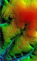
We deliver advanced digital maps optimized for smartphones, serving hunters, hikers, and landowners. Our cartography integrates LiDAR data and topographic details for engineering, real estate, and recreational use. Custom solutions include 3D modeling and Autocad file exports.
Geology Surveys
Specialized geologic mapping covers cave systems, Karst aquifers, and Edwards Aquifer recharge zones. Fieldwork and well data analysis inform environmental compliance and land-use planning. Our surveys support TCEQ requirements and watershed drainage assessments.
Watershed Mapping
Using LiDAR technology, we analyze watershed drainage networks to identify flood-prone areas and soil erosion patterns. This data supports sustainable development and regulatory compliance for landowners and municipalities across Central Texas.
People
Andy Grubbs
Founder
Andy Grubbs has worked in Texas geology since 1981, specializing in cave systems and Karst aquifers. He designed septic systems starting in 1997 and holds three key industry licenses. His expertise bridges environmental compliance, land-use planning, and digital mapping technologies.
Questions
What is a Facility Planning Report?
A Facility Planning Report studies land features required by counties for new lot plat approval, prepared by licensed professionals like Registered Sanitarians.
Can I install a standard septic system with less than 4 feet of soil?
Yes, alternatives like low-pressure dose or mound systems work but cost more than aerobic systems.
How do I get a septic system designed for my property?
Contact us for a site evaluation, data collection, and customized design based on soil conditions and regulatory requirements.
Do you provide digital maps for outdoor activities?
Yes, we offer smartphone-compatible topographic maps for hunting, hiking, and ranch management through Topo Cheapo.
What watershed mapping services do you offer?
We use LiDAR to analyze drainage patterns and flood risks, supporting sustainable land development and environmental protection.