Business Details
19 Years
experience
Emergency
services
Your Trusted Partner for Land Surveying Solutions
At Strick & Company & Company, we prioritize professionalism and integrity while delivering precise land surveying solutions tailored to our clients' needs. Established in 2007, our firm specializes in boundary dispute resolution, construction layouts, topographic surveys, and infrastructure projects across Missouri and Kansas, with a focus on the Kansas City metropolitan area. Our licensed team combines technical expertise with a collaborative approach to ensure accuracy and efficiency for projects ranging from transportation systems to commercial developments.We maintain partnerships with geotechnical firms and civil engineers to enhance service capabilities, while our commitment to client satisfaction is reflected in our repeat business and industry testimonials. Our mission is to serve as an extension of our clients' teams, providing reliable data and timely execution for every project phase.

Services
Boundary Surveys
Construction Layouts
Topographic Surveys
ALTA/ACSM Surveys
Subdivision Platting
GPS/GIS Surveys
Elevation Certificates
Telecommunication Site Surveys
Highway Alignment Surveys
Floodplain Mapping
Details
- Year established: 2007
Highlights and features
- We have over 15 years of experience in land surveying
- Licensed professionals operating in Missouri and Kansas
- Emergency services available to prevent project delays
- Specialized teams for diverse surveying needs
- Proven track record with infrastructure projects valued in millions
What people say
Second to none
Accurate and timely
Exemplary work
Best company
Goes the extra mile
Services
Boundary Surveys
We conduct comprehensive boundary surveys to establish property lines, resolve disputes, and support land development projects. Our services include ALTA/ACSM standards compliance, ownership mapping, and easement identification. Clients benefit from precise monument recovery and legal documentation that meets municipal requirements.
Construction Layouts
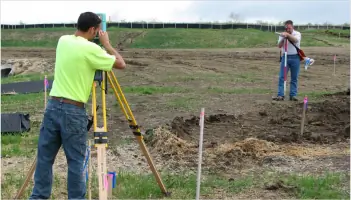
Our construction layout services provide accurate field positioning for infrastructure projects. We support grading, utilities, and structural elements using GPS technology and conventional instruments. Clients receive clear reference points that minimize rework and ensure adherence to design specifications during all project phases.
Topographic Surveys
We create detailed topographic maps showing natural and man-made features for engineering and architectural projects. Our surveys include elevation data, vegetation, and utilities using modern GPS and total station equipment. Clients receive digital deliverables compatible with CAD software for seamless design integration.
GPS/GIS Surveys
Our GPS/GIS services include control network establishment, photogrammetric control, and utility mapping. We integrate field data with GIS platforms for municipal water systems and infrastructure projects. Clients benefit from accurate spatial data management and customized mapping solutions for planning and analysis.
Subdivision Platting
We prepare subdivision plats and lot splits in compliance with local regulations. Our services include municipal coordination, legal description preparation, and final plat production. Clients receive professionally executed documents that streamline approval processes and ensure marketability of developed parcels.
Questions
What surveying services do you offer?
We provide boundary surveys, construction layouts, topographic mapping, ALTA/ACSM surveys, and subdivision platting for infrastructure and development projects.
Which areas do you serve?
We operate throughout Missouri and Kansas, with primary focus on the Kansas City metropolitan area for land surveying projects.
Do you handle emergency surveying needs?
Yes, we maintain flexible scheduling to address urgent survey requirements and prevent construction project delays.
What industries do you work with?
We serve developers, contractors, municipalities, and private clients on transportation, utilities, schools, and commercial infrastructure projects.