
Business Details
24 Years
experience
Your Trusted Land Surveying Partner in Illinois and Wisconsin
Land Surveying Services was established in 2002 by a team with over 20 years of combined experience in land surveying. Our mission is to be the preferred provider of land surveying services through timely, accurate, and cost-effective solutions. We invest in cutting-edge technology, including Geodimeter Robotic Total Stations, Topcon GPS systems, and AutoCAD software, to deliver precise results. Our services span residential, commercial, and industrial projects across Illinois and Wisconsin, with capabilities in ALTA/ACSM surveys, subdivision design, construction layout, and hydrographic surveys. We maintain direct communication between field crews and office staff through mobile technology, ensuring seamless project execution.Our team includes licensed professionals with specialized expertise in boundary surveys, condominium surveys, and settlement monitoring. We prioritize continuing education to stay current with industry standards and client-specific requirements. Our project managers oversee assignments from start to finish, guaranteeing adherence to deadlines and customized deliverables. We offer flexible output formats including DWGs, PDFs, and DWFs, with physical shipments via UPS. With multiple field crews and a commitment to client collaboration, we ensure efficient completion of projects of any scale.


Services
ALTA/ACSM Surveys
Boundary Surveys
Construction Layout
Hydrographic Surveys
Subdivision Design
Condominium Surveys
Settlement Monitoring
Wireless Site Surveys
Plat Creation
Topographic Mapping
Details
- Year established: 2002
Highlights and features
- 20 years of combined experience in land surveying
- State-of-the-art field equipment and AutoCAD software
- Multiple field crews for timely project completion
- Customizable survey deliverables in any requested format
- Direct field-to-office communication via mobile technology
Associations and certifications
- Illinois Unified Certification Program
- City of Chicago
- IDOT
- CTA
- Metra
- Pace
Services
ALTA/ACSM Land Title Surveys
We conduct ALTA/ACSM-compliant land title surveys to identify property boundaries, easements, and encroachments. Our surveys meet national standards for commercial real estate transactions. Clients receive detailed maps with precise legal descriptions.
Construction Layout
Our construction layout services establish accurate reference points for building projects. We use robotic total stations and GPS technology to mark foundations, utilities, and structural elements. This ensures compliance with architectural plans and zoning regulations.
Hydrographic Surveys
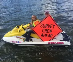
We map underwater terrain for riverbeds, lakes, and coastal areas. Our hydrographic surveys support infrastructure projects and environmental assessments. Data collection includes depth measurements and submerged feature identification.
Boundary Surveys
Our boundary surveys determine legal property lines using historical records and field measurements. We identify existing markers and resolve disputes through precise documentation. Clients receive certified maps for real estate transactions or development.
Subdivision Design
We create subdivision plans that divide large parcels into buildable lots. Our designs comply with municipal codes and include road access, utility placement, and green space allocation. We coordinate with local authorities for plat approval.
People
Gloria Jean Koter
President
Licensed Professional Land Surveyor with extensive experience in boundary determination and construction layout. Oversees firm operations and maintains industry certification standards.
Brittney T. Koter
Director of Operations
Licensed in Illinois and Wisconsin with expertise in CAD software and surveying technology. Manages project workflows and client coordination since earning her 2023 Wisconsin license.
Elizabeth Retzer
Field Manager
20-year industry veteran with expertise in GPS surveying and construction layout. Manages field crews and office drafting operations while maintaining client scheduling efficiency.
Questions
What qualities should I look for in a surveying company?
Look for a good reputation, industry experience, and availability to meet your project deadlines.
How do I place an order for surveying services?
Orders can be placed by phone, fax, email, or through our website for convenience.
What factors determine surveying costs?
Cost depends on survey type, property size, terrain, vegetation, accessibility, and seasonal conditions.
Do you offer volume-based pricing discounts?
Yes, we provide tiered pricing based on anticipated order volume for our clients.
What is your standard turnaround time?
Our standard turnaround is two weeks, with flexibility to accommodate urgent deadlines.
How will I receive my survey deliverables?
We provide digital files via email and physical shipments through UPS in requested formats.
Videos