Business Details
26 Years
experience
Expert Land Surveying Services in Sarasota, FL
Established in 2000, MSB Surveying has grown exponentially by leveraging cutting-edge GPS, robotic, and GIS technologies to deliver precise and reliable surveying solutions. Our team of seasoned professionals brings decades of combined experience in boundary research, hydrographic mapping, and construction layout, serving both public and private sectors across Florida. We prioritize ethical standards and client satisfaction, maintaining long-term relationships through transparent communication and adherence to state regulations.Our expertise spans historical land research, FEMA elevation certifications, and complex ALTA/ACSM surveys, ensuring clients receive tailored solutions for residential, commercial, and municipal projects. With a focus on innovation and accuracy, we navigate permitting processes for environmental agencies and local municipalities, supporting clients from initial planning to project completion.
Services
Boundary Surveys
Topographic Surveys
Hydrographic Surveys
Subdivision Platting
Residential Construction Layout
As-Built Surveys
Quantity Surveys
FEMA Elevation Certificates
ALTA/ACSM Surveys
Riparian Line Surveys
Details
- Year established: 2000
Highlights and features
- 25 years of experience in land surveying and mapping
- Utilize advanced GPS and robotic technology for accuracy
- Experienced team with expertise in boundary and hydrographic surveys
- Commitment to ethical standards and client-focused solutions
- Proven track record with complex projects for municipalities and developers
Associations and certifications
- State of Florida Land Surveyor License #5538
- State of Florida Licensed Business #7044
What people say
Outstanding quality
Unparalleled professionalism
Accurate and timely
Thorough research
Expertise in boundary disputes
Services
Boundary Surveys
Boundary surveys establish or re-establish property lines and monuments, resolving disputes and supporting mortgage closings, permits, and land divisions. Our team uses advanced GPS and robotic technology to ensure precision, adhering to Florida regulations. Clients benefit from clear documentation that protects property rights and simplifies legal processes.
Hydrographic Surveys
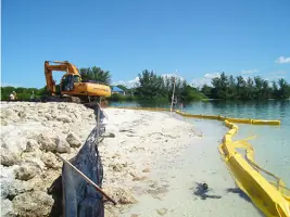
Hydrographic surveys map submerged lands, including seagrass, oyster beds, and elevations, to support dock permits and dredging projects. We employ specialized equipment to collect accurate underwater data, ensuring compliance with environmental agencies. Clients receive detailed maps that streamline permitting and construction in coastal areas.
FEMA Elevation Certificates
FEMA Elevation Certificates provide critical elevation data for flood insurance requirements. Our surveys meet federal standards, helping homeowners and developers assess flood risks and secure insurance. Accurate measurements reduce costs and ensure compliance with local floodplain management regulations.
ALTA/ACSM Surveys
ALTA/ACSM surveys meet national standards for title insurance, detailing property boundaries, improvements, and easements. We collaborate with title companies to deliver precise maps that support real estate transactions. Clients gain confidence in property investments through comprehensive, lender-approved documentation.
Topographic Surveys
Topographic surveys map terrain features and elevations for drainage planning and construction projects. Using robotic and GPS tools, we create detailed contour maps that guide development. Clients rely on our data to design infrastructure and comply with municipal permitting requirements.
People
Martin Scott Britt
Owner/President/Surveyor & Mapper
With 46 years of experience, Scott founded MSB Surveying and specializes in boundary disputes, hydrographic surveys, and ALTA/ACSM standards. He serves as an expert witness and educator in Florida's surveying community.
Richard Abernathy
Vice-President
A University of Florida graduate, Richard oversees field operations and CADD teams. His expertise includes coastal surveys, riparian rights, and digital terrain modeling across Sarasota and Manatee Counties.
Sandra Britt Culpepper
Office Manager
With 30+ years in surveying, Sandy manages daily operations and technical aspects of site plans, boundary surveys, and FEMA certifications, ensuring seamless project execution.
Jan Ruggiero
GIS Manager
Jan manages MSB's GIS systems, integrating workflows to enhance productivity. Her background in architectural engineering and environmental sciences supports advanced digital surveying solutions.
James Copeland
Head Crew Chief
Josh supervises field crews and proposal estimates with 24 years of experience in boundary surveys and construction stake-outs, combining military precision with local expertise.
Questions
What types of surveys does MSB Surveying offer?
We provide boundary, topographic, hydrographic, ALTA/ACSM, FEMA elevation, and subdivision surveys, among others, tailored to residential, commercial, and municipal needs.
How does MSB handle complex boundary disputes?
Our team uses historical research, GPS technology, and expert witness testimony to resolve disputes, ensuring legally defensible and accurate property line determinations.
Can MSB assist with permitting through local municipalities?
Yes, we guide clients through permitting processes for agencies like the Army Corps of Engineers and Southwest Florida Water Management District, ensuring compliance and efficiency.
What technology does MSB use for surveys?
We employ GPS, robotic total stations, GIS systems, and hydrographic equipment to deliver precise, high-tech surveying solutions for all project types.
How long has MSB Surveying been in business?
MSB Surveying has served Florida since 2000, with team members boasting decades of combined experience in the industry.