Business Details
22 Years
experience
Emergency
services
Expert Geospatial Services in Tampa, FL
SurvTech Solutions is a premier geospatial firm dedicated to delivering precise and innovative surveying solutions. Since 2004, we have combined advanced technology with a team of highly skilled professionals to meet the diverse needs of our clients across the Southeastern United States. Our services span land, hydrographic, aerial, and subsurface utility surveying, supported by cutting-edge tools like LiDAR, UAVs, and ground-penetrating radar.We prioritize safety, client collaboration, and operational excellence, ensuring projects are completed efficiently and to the highest standards. With licenses in 11 states and federal certifications, we provide consistent, reliable service for complex projects in challenging environments.
Services
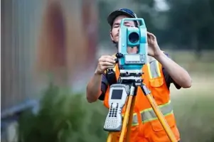
Land Surveying
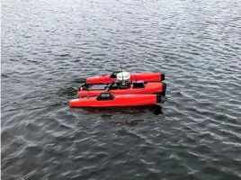
Hydrographic Surveys
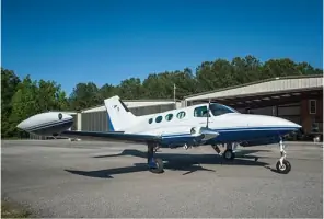
Aerial Mapping
Subsurface Utility Mapping
3D Laser Scanning
GIS Services
Metrology
Geophysical Mapping
UAV Surveying
Subsurface Utility Engineering
Details
- Year established: 2004
Highlights and features
- We offer over 20 years of experience in geospatial services.
- Our team utilizes cutting-edge technology for accurate surveys.
- Licensed in 11 states for consistent, nationwide service.
- Certified Federal Surveyors with NAICS code 541370.
- Equipped for challenging environments, including acidic water and remote areas.
Associations and certifications
- Certified Federal Surveyor (CFedS)
What people say
Amazing people
Quality of work superb
Professional and amazing
Hands-on owners
Best solution for projects
Services
Land Surveying
Our land surveying services utilize GPS, LiDAR, and UAV technology to map boundaries, topography, and construction sites. We specialize in ALTA/NSPS standards, cadastral surveys, and high-accuracy mapping for engineering and development projects. Clients benefit from rapid deployment and data in requested formats for seamless project progression.
Hydrographic Surveys
We conduct hydrographic surveys using manned and unmanned vessels equipped with sonar, LiDAR, and interferometric systems. Our expertise includes bathymetric modeling, submerged utility detection, and coastal erosion analysis. Projects benefit from centimeter-level accuracy and integration with above-water elevation data for comprehensive environmental assessments.
3D Laser Scanning
Our terrestrial and mobile LiDAR systems capture millions of data points per second, creating detailed 3D models for construction, mining, and forensic analysis. Deliverables include point clouds, BIM models, and virtual reality simulations. This non-contact method ensures safety and efficiency in hazardous or complex environments.
Subsurface Utility Engineering
Using GPR, EM, and vacuum excavation, we locate and map underground utilities to prevent costly disruptions. Our SUE services meet ASCE standards and include risk assessments for construction projects. Clients receive color-coded site markings and GIS-integrated data to enhance project safety and compliance.
Aerial Mapping
FAA-certified UAVs and aircraft equipped with LiDAR and photogrammetry software provide rapid aerial mapping for large-scale projects. Applications include topographic surveys, volumetric calculations, and infrastructure inspections. Data is processed into DEMs, orthomosaics, and 3D models for engineering and environmental planning.
People
David O'Brien
President/Co-Founder
With 25+ years in surveying, David co-founded SurvTech in 2004. A licensed surveyor in 11 states and LEED AP-certified, he drives innovation in geospatial technology and federal project execution.
Stacy Brown
Vice President/Co-Founder
Stacy brings 20+ years of expertise in boundary, hydrographic, and construction surveys. Her technical proficiency and leadership ensure SurvTech's adherence to rigorous industry standards and client satisfaction.
Matthew Brooks
V.P. Contracts Management
A licensed surveyor in FL, NY, and ME, Matthew specializes in cadastral surveys and USACE projects. He oversees contract compliance and project delivery, ensuring technical and administrative excellence.
Darron Goss
Hydrographic Department Manager
With 30+ years in hydrographic surveying, Darron leads data collection for volumetric analysis and machine control models. His expertise supports complex coastal and inland waterway projects.
Fabiano Santos
3D Scanning Department Manager
Fabiano has 16+ years in LiDAR and digital twin technology. He directs SurvTech's reality capture initiatives, delivering high-accuracy 3D models for industrial and infrastructure applications.
Questions
What geographic areas does SurvTech serve?
SurvTech operates in Florida, Georgia, Alabama, Louisiana, Mississippi, Texas, Colorado, and other Southeastern and Midwestern states, with nationwide federal project capabilities.
What technologies does SurvTech use for surveys?
We employ LiDAR, UAVs, ground-penetrating radar, sonar, and GPS systems to deliver high-accuracy data across land, water, and subsurface environments.
Are SurvTech's surveyors certified?
Our team includes Certified Federal Surveyors (CFedS), licensed professionals in 11 states, and specialists with OSHA, MSHA, and TWIC certifications for secure site access.
Can SurvTech handle emergency surveying projects?
Yes, we deploy rapidly to challenging environments, including acidic water conditions and remote locations, with 24/7 availability for urgent needs.
What industries benefit from SurvTech's services?
We support construction, energy, environmental, government, and infrastructure sectors with tailored geospatial solutions for complex projects.
Videos