Business Details
11 Years
experience
Professional Surveying, Mapping & Solutions in Alabama, Florida, Mississippi, and Georgia
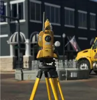
Pike Land Service, Inc. is a professional surveying, mapping, and solutions firm established in 2015 by Cory Rushing. Originally based in Troy, Alabama, we have expanded our operations to include offices in Dothan and Baldwin County, Alabama, as well as Panama City Beach, Florida. Our team utilizes cutting-edge surveying equipment and modern technology to deliver high-quality, ready-to-use products tailored to meet the specific needs of our clients across Alabama, Florida, Mississippi, and Georgia. With licensed professionals in all four states, we pride ourselves on providing excellent customer service and ensuring the accuracy and reliability of our deliverables. Our staff brings decades of combined experience in the surveying profession, allowing us to manage a wide variety of projects professionally and competently.From boundary surveys to geodetic control, our capabilities span the full spectrum of land management and development needs. We are committed to maintaining the highest standards of professionalism and technical excellence in every project we undertake. Our approach combines thorough research, advanced technology, and meticulous attention to detail to produce results that meet regulatory requirements and exceed client expectations. We specialize in providing solutions that help clients avoid costly mistakes during development through precise data collection and analysis. Our dedication to continuous improvement and client satisfaction has established us as a trusted partner in the surveying industry.
Services
Boundary Surveys
Construction Staking
ALTA Surveys
Topographical Surveys
Subdivision Platting
GIS Data Collection
As-Built Surveys
Flood Certificates
Geodetic Surveys
Details
- Year established: 2015
Highlights and features
- We have licensed surveyors in Alabama, Florida, Georgia, and Mississippi.
- Our team uses cutting-edge surveying equipment and modern technology.
- We provide tailored solutions for land management and development projects.
- Our staff has decades of combined experience in professional surveying.
- We ensure compliance with regulatory requirements and industry standards.
Services
Boundary Surveys
Boundary Surveys determine property lines using public records and field measurements. Our team researches historical documents and conducts precise fieldwork to establish or verify existing boundaries. This service ensures legal compliance and prevents disputes during property transactions or development projects.
Construction Staking
Construction Staking locates reference points for new developments. We mark boundaries and existing structures to guide construction crews. This service improves project efficiency by preventing rework and ensuring proper placement of infrastructure like roads and buildings.
ALTA Surveys
ALTA Surveys meet national standards for commercial property transactions. We map boundaries, easements, and improvements to satisfy title insurance requirements. This service provides comprehensive documentation for complex real estate deals and development projects.
Topographical Surveys
Topographical Surveys document natural and man-made features of land. We measure elevations, water bodies, and structures to create detailed maps. This service supports development planning and helps obtain necessary permits from local agencies.
Subdivision Platting
Subdivision Platting creates legal documents for dividing land. We prepare scaled maps showing lot boundaries and access points. This service ensures compliance with zoning regulations and facilitates property sales or development.
People
Cory Rushing
Owner/President
Cory Rushing founded Pike Land Service, Inc. in 2015 with over 20 years of surveying experience. He oversees operations and ensures technical excellence across all projects.
Mandy Blackmon
VP of Operations
Mandy Blackmon manages daily operations and client relations. Her leadership ensures efficient project execution and maintains high service standards across multiple states.
Justin Thomley
VP of Surveying
Justin Thomley leads surveying teams with expertise in boundary determination and construction staking. He ensures technical accuracy and compliance with industry standards.
Sarah Wicker
Project Manager
Sarah Wicker coordinates complex projects from planning to delivery. Her attention to detail ensures timely completion of surveys that meet client specifications and regulatory requirements.
Questions
What services does PLS Group, Inc. offer?
We provide boundary surveys, construction staking, ALTA surveys, topographical mapping, subdivision platting, and other surveying services for land development projects.
In which states do you operate?
Our licensed professionals serve clients across Alabama, Florida, Mississippi, and Georgia.
How do you ensure survey accuracy?
We use cutting-edge GPS technology and follow rigorous quality control processes to guarantee precise measurements and reliable deliverables.
What technology do you use?
Our equipment includes GPS systems, 3D laser scanners, and advanced mapping software to ensure accurate data collection and analysis.
Can you handle complex commercial projects?
Yes, we specialize in ALTA surveys and other complex commercial projects requiring detailed documentation and regulatory compliance.
How do you support land development?
We provide topographic surveys, flood certificates, and as-built documentation to help clients meet permitting requirements and avoid costly mistakes.