Business Details
13 Years
experience
Expert Geospatial Services for Land Surveying, GIS, LiDAR & Utility Locating
GIS Surveyors is a multifaceted geospatial firm committed to delivering precise and innovative solutions through our expertise in land surveying, GIS, LiDAR, and utility locating. Founded in 2013 and headquartered in San Diego, California, we operate from additional offices in Los Angeles, Seattle, and Cincinnati, providing nationwide service. As a Service-Disabled Veteran-Owned Small Business (SDVOSB) and Employee Stock Ownership Plan (ESOP) company, we prioritize fiscal responsibility, exceptional customer service, and a client-first mindset. Our team comprises certified GIS professionals, licensed surveyors, and specialists in remote sensing and public infrastructure asset management, ensuring we meet the highest industry standards. With over a decade of combined experience, our staff has cultivated a culture of excellence that distinguishes us in the geospatial industry.We pride ourselves on our ability to integrate complementary technologies, offering clients the convenience and efficiency of a one-stop shop for all geospatial needs. Our national presence and growth are driven by a commitment to innovation and a deep understanding of the evolving demands of public works, energy, and infrastructure projects. We are honored to serve municipalities, utilities, and government agencies as a trusted partner, delivering tailored solutions that exceed expectations. Our certifications, including DVBE and SLBE, underscore our dedication to diversity and local business development. At GIS Surveyors, we remain steadfast in our mission to provide accurate measurements and reliable data that empower our clients to achieve their objectives.

Services
Land Survey
GIS
LiDAR
Utility Locating
UAV/UAS Mapping
As-Built Survey
Topographic Survey
Boundary/ALTA Surveys
Geodatabase Design
Subgrade Locating
Details
- Year established: 2013
Highlights and features
- We are a Service-Disabled Veteran-Owned Small Business (SDVOSB) with a client-first mindset.
- Our team includes certified GIS professionals and licensed surveyors.
- Employee-owned company ensuring dedicated, high-quality service delivery.
- Full-service geospatial approach providing convenience and efficiency.
- Recognized expertise in LiDAR and underground utility locating.
Associations and certifications
- SDVOSB
- DVBE
- SLBE
Services
Land Survey
Land Survey services involve precise measurements and mapping of terrestrial features using traditional and modern techniques. Our FAA-certified UAS pilots and licensed surveyors deliver topographic surveys, boundary delineation, construction staking, and as-built surveys. Clients benefit from accurate data essential for infrastructure planning, legal documentation, and project execution.
GIS
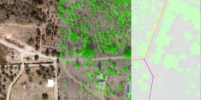
GIS services encompass geodatabase design, spatial analysis, and 2D/3D modeling to visualize and interpret location-based data. We transform raw data into actionable insights for urban planning, environmental management, and utility operations. Clients gain enhanced decision-making capabilities through tailored mapping solutions and data integration.
LiDAR
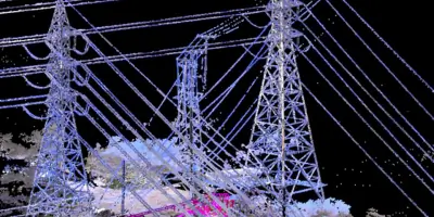
LiDAR services utilize laser scanning to create high-resolution topographic maps and 3D models. Our experts analyze data for vegetation management, terrain modeling, and infrastructure design. Clients receive detailed spatial insights that improve project accuracy and efficiency in sectors like energy, environmental monitoring, and civil engineering.
Utility Locating
Utility Locating identifies underground infrastructure using ground-penetrating radar and radio locators. This service prevents conflicts during construction by mapping subgrade utilities accurately. Clients ensure project safety and regulatory compliance with verified data, reducing risks and delays in excavation projects.
UAV/UAS Mapping
UAV/UAS Mapping employs drones to capture aerial data for large-scale projects. Licensed operators generate detailed orthomosaics and elevation models, ideal for monitoring expansive sites like pipelines and infrastructure corridors. Clients gain cost-effective, time-efficient data collection with high-resolution outputs for precise analysis.
People
Paul Loska
Chief Executive Officer
Paul Loska, CEO and co-founder, has 30 years of land surveying expertise. A veteran of Operation Desert Storm, he leads GIS Surveyors' strategic vision and growth, emphasizing client partnerships and a culture of excellence.
Matthew Van Eck
Chief Technical Officer
Matthew Van Eck, co-founder and CTO, oversees GIS, LiDAR, and survey operations. With two decades of experience, he specializes in GIS programs for Fortune 500 companies and municipal projects, ensuring client-focused technical solutions.
Dennis Rose
Director of Survey
Dennis Rose directs survey operations with over 19 years of experience. A California-licensed surveyor, he manages critical infrastructure projects, blending field expertise with advanced technologies to maintain high accuracy and client satisfaction.
Dan Bellissemo
Director of LiDAR and Remote Sensing
Dan Bellissemo leads LiDAR initiatives with 30+ years in geospatial project management. His expertise spans defense, government, and commercial sectors, delivering innovative LiDAR solutions for complex engineering and mapping challenges.
Gavin McKellar
Field Operations Manager
Gavin McKellar oversees field crews with nearly 30 years of survey experience. Proficient in GPS and terrestrial methods, he ensures crews meet safety and quality standards, supporting nationwide projects with technical expertise and operational efficiency.
Questions
What services does GIS Surveyors offer?
We provide land surveying, GIS, LiDAR, and utility locating services, utilizing advanced technologies to deliver accurate geospatial data for infrastructure, energy, and public works projects.
Is GIS Surveyors a veteran-owned business?
Yes, we are a Service-Disabled Veteran-Owned Small Business (SDVOSB) certified, reflecting our commitment to excellence and service-oriented leadership values.
What industries do you serve?
Our clients include municipalities, utilities, government agencies, and Fortune 500 companies, supporting projects in energy, wastewater, transportation, and public infrastructure sectors.
Are your teams certified professionals?
Our staff includes licensed surveyors, certified GIS professionals, and experts in remote sensing and asset management, ensuring adherence to the highest industry standards.
How does GIS Surveyors handle utility locating?
We use state-of-the-art equipment like ground-penetrating radar and radio locators to map subgrade utilities in one trip, reducing costs and delays for clients.
What is your experience with federal projects?
We have extensive capabilities supporting federal agencies, offering innovative GIS and LiDAR processing solutions for environmental, infrastructure, and energy initiatives.
Videos