
Business Details
44 Years
experience
Your Trusted Surveyors in Newberry, SC
Abraham Land Surveying has been serving South Carolina for nearly four decades, delivering precise geospatial solutions tailored to residential, commercial, and industrial needs. Our expertise spans traditional land surveying, GIS infrastructure development, UAV LiDAR technology, and custom software applications, ensuring clients receive innovative and reliable services. Founded in 1982 by Tom Abraham, our firm combines family values with cutting-edge technology to exceed expectations in accuracy and client satisfaction. We have cultivated long-term relationships with individuals, corporations, and government entities through our commitment to quality and dependability. Our team's deep industry experience, including early adoption of robotic instrumentation and drone-based LiDAR, positions us as leaders in modern surveying practices.With a focus on both large-scale projects and personalized service, we support clients ranging from local families to Fortune 500 companies. Our work on high-profile projects, such as the V.C. Summer Nuclear Plant and Samsung supplier developments, underscores our technical proficiency and trustworthiness. We maintain transparency in operations and prioritize client communication to streamline complex geospatial challenges. Our geographic information systems expertise extends to asset inventories, indoor mapping, and crisis management applications, demonstrating versatility across sectors. As a locally rooted business, we remain dedicated to advancing our community's infrastructure while expanding our technological capabilities globally.

Services
Land Surveying
GIS Services
UAV LiDAR
Custom Software Development
Infrastructure Inventories
Wetlands Delineation
Ortho-Imagery
Geodatabase Construction
Project Scouting Reports
Topographic Mapping
Details
- Year established: 1982
Highlights and features
- We have nearly 40 years of experience in geospatial services across South Carolina.
- Our team pioneered UAV LiDAR technology adoption in the region.
- We develop custom software applications for utility management and crisis communication.
- Our work supports major infrastructure projects like the V.C. Summer Nuclear Plant.
- We maintain long-term relationships with both local families and Fortune 500 companies.
What people say
Excellent attention to detail
Instrumental in dealing with FEMA
Accurate surveying work
Latest technology adoption
Meet accelerated deadlines
Services
Land Surveying
Our land surveying services encompass boundary determination, infrastructure inventories, and wetlands delineation using advanced GPS and robotic instrumentation. Clients benefit from precise measurements for property development, construction projects, and legal documentation. With decades of experience, we ensure compliance with state regulations and deliver reliable data for residential, commercial, and industrial applications.
GIS Services
We provide comprehensive GIS services including geodatabase construction, aerial imagery georeferencing, and asset inventory mapping. Our team creates detailed topographic maps and indoor spatial representations for schools, banquet centers, and utility networks. These solutions support urban planning, environmental management, and efficient infrastructure maintenance through accurate spatial data analysis.
UAV LiDAR
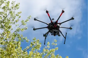
Our UAV LiDAR technology captures 18 million data points per minute, offering ultra-detailed terrain analysis through ortho-imagery and vegetation-penetrating measurements. This solution enables precise topographic modeling for construction planning, flood risk assessment, and environmental monitoring. Clients gain actionable insights from high-resolution 3D maps generated efficiently and cost-effectively.
Custom Software Development
We develop tailored software applications for utility work order management, 811 ticket systems, and public crisis communication platforms. These tools streamline data collection, improve regulatory compliance, and enhance stakeholder collaboration. Our solutions integrate geospatial data with user-friendly interfaces to optimize operational efficiency for government and private sector clients.
Project Scouting Reports
Our project scouting reports combine UAV aerial data and LiDAR analysis to assess site conditions for development planning. These reports identify terrain challenges, environmental constraints, and infrastructure requirements to inform decision-making. Clients use this information to optimize project timelines, reduce costs, and ensure regulatory compliance during land development processes.
People
Tad Abraham
President
Tad Abraham leads Abraham Land Surveying's technological innovation, introducing robotic instrumentation and UAV LiDAR to South Carolina. With expertise in graphic communications, he enhances client deliverables through advanced visualization techniques. His commitment to precision and modern surveying methods ensures the firm's continued leadership in geospatial services.
Tom Abraham
Founder
Tom Abraham founded the company in 1982 after serving with the US Navy Seabees. His decades of field experience in survey control and construction QC informs the firm's practical approach to complex projects. He remains actively involved in daily operations, maintaining the company's core values of reliability and technical excellence.
Questions
What geospatial services does Abraham Land Surveying offer?
We provide land surveying, GIS mapping, UAV LiDAR technology, custom software development, and project scouting reports for residential, commercial, and industrial clients.
How long has the company been in business?
Abraham Land Surveying has served South Carolina since 1982, providing geospatial solutions for nearly 40 years.
What technology does the firm use?
We utilize robotic instrumentation, UAV LiDAR capturing 18 million points per minute, and custom software applications for data management and analysis.
Do you work with both individuals and corporations?
Yes, we serve local families, multi-billion dollar corporations, and government entities with equal attention to detail and accuracy.
What makes your services unique?
Our combination of 40-year experience, early adoption of LiDAR technology, and custom software solutions differentiate our comprehensive geospatial offerings.