Business Details
23 Years
experience
Emergency
services
Your Trusted Partner for Civil Engineering Solutions
Bracken Engineering is a dedicated civil engineering and land surveying firm committed to excellence in site development and consulting services. With a strong focus on surveying, engineering, drone photogrammetry, and environmental permitting, we guide clients through the entire property development journey from inception to completion. Our team of licensed professionals brings decades of combined experience and expertise to serve diverse sectors including commercial, retail, industrial, and residential developments. We prioritize effective communication, community engagement, reasoned problem-solving, and empathy for client needs. Our commitment to advanced technology, such as GPS, robotic surveying, and drone-based mapping, ensures precision and efficiency.We specialize in navigating complex environmental regulations while maintaining a strong dedication to environmental stewardship. With offices in Southeastern Massachusetts, Cape Cod, and the Islands, we deliver tailored solutions for architects, developers, real estate agents, attorneys, and homeowners. Our corporate mantra C.A.R.E. (Communication, Awareness, Reason, Empathy) guides every project. We balance technical proficiency with ethical practices, regulatory compliance, and community responsibility to achieve sustainable outcomes.
Services
Land Surveying
Civil Engineering
Environmental Permitting
Drone Photogrammetry
Topographic Surveys
Construction Layout
Septic System Design
Coastal Stabilization
Floodplain Analysis
ALTA Surveys
Details
- Year established: 2003
Highlights and features
- We offer 30+ years of combined experience in civil engineering and land surveying.
- Our team uses advanced drone photogrammetry and ground-penetrating radar technology.
- We specialize in navigating complex environmental permitting processes.
- Our engineers are licensed and certified in specialized areas like floodplain management.
- We provide tailored solutions for diverse clients across Southeastern Massachusetts.
Services
Land Surveying
Our land surveying team provides precise boundary determinations, construction layout, and topographic mapping using GPS, robotic, and drone technologies. Specializing in ALTA surveys, Land Court plans, and aerial photogrammetry, we support commercial and residential developments. Our licensed surveyors ensure accuracy for real estate transactions and construction projects across Cape Cod and Southeastern Massachusetts.
Civil Engineering
We deliver comprehensive civil engineering solutions from project concept to completion, including site planning, drainage design, and infrastructure development. Our services cover septic systems, road design, and condominium developments for both private and municipal clients. Utilizing advanced software like Civil3D, we ensure compliance with local and state regulations across Massachusetts.
Environmental Permitting
Our environmental permitting specialists navigate complex regulatory requirements for coastal and inland projects. We handle Chapter 91 licenses, floodplain permits, and wetland mitigation plans while balancing development goals with ecological protection. Our team ensures compliance with state and federal regulations for projects in sensitive coastal resource areas.
Drone Photogrammetry
We employ FAA-certified drone pilots and photogrammetry technology to create detailed site models and topographic maps. This advanced technique improves survey accuracy, reduces field time, and provides enhanced visualization for large-scale developments, coastal assessments, and construction monitoring across our service regions.
Coastal Stabilization
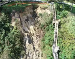
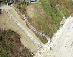
Our coastal engineering team designs erosion control solutions for bluffs and shorelines using environmentally sensitive approaches. We combine structural techniques with natural restoration methods to protect coastal properties while maintaining ecosystem integrity. Services include erosion analysis, seawall design, and permitting for coastal resource areas.
People
Don Bracken, Jr.
Company Owner and President
With over 30 years of civil engineering experience, Don founded Bracken Engineering in 2003. A licensed professional engineer and surveyor, he oversees project coordination and management while maintaining active involvement in community service and professional organizations.
Zachary Basinski
Senior Project Manager and Engineer
A certified floodplain manager with 20+ years of experience, Zac specializes in climate-resilient design solutions. He manages projects from concept to completion while maintaining active roles in professional associations and community scouting programs.
Alan M. Grady
Senior Land Surveyor
Alan brings 40+ years of surveying expertise, specializing in boundary determinations and Land Court surveys. A veteran of the U.S. Army's mapping school, he combines traditional methods with modern technology to deliver precise survey solutions.
David A. French, Jr.
Survey Manager
With 30+ years in the field, David manages survey operations and field crews. A licensed professional surveyor since 2022, he combines technical expertise with leadership experience to ensure quality control across all surveying projects.
Robert E. Dewar
Project Manager and Engineer
Rob has 7+ years of project management experience, specializing in residential and commercial developments. His background includes construction management and municipal engineering, bringing practical insights to project coordination and client relations.
Questions
What geographic areas do you serve?
We serve Southeastern Massachusetts, Cape Cod, and the Islands, with offices in Bourne, Nantucket, and Mansfield.
What services does Bracken Engineering provide?
Our core services include land surveying, civil engineering, environmental permitting, drone photogrammetry, and coastal stabilization projects.
Do you handle emergency restoration projects?
Yes, we've completed emergency stabilization projects like the 2022 Manomet Bluff restoration in Plymouth, MA.
How do you handle environmental permitting?
Our team navigates complex permitting processes while balancing development goals with environmental protection requirements for coastal and inland projects.
What technology do you use?
We utilize GPS, robotic surveying, drones, ground-penetrating radar, and advanced design software like Autodesk Civil3D for precise results.
Can you handle both small and large projects?
Yes, we work with clients from individual homeowners to large commercial developers across various project scales and complexities.