
Business Details
13 Years
experience
Your Trusted Civil Engineering Partner in Alabama
Founded in 2013, Civil Southeast began as a vision shared by two civil engineers committed to excellence and service. Our team, led by Jeremy McMath, operates with a foundation of trust, faith, and technical expertise, delivering civil engineering, project management, and land surveying solutions. Over the years, we have expanded our reach across Alabama and Northwest Florida, serving diverse clients from corporations to individuals. Our approach combines decades of combined experience with a client-centric philosophy, ensuring precision and reliability in every project.We prioritize prompt service, attention to detail, and deliverables tailored to client needs, fostering long-term partnerships. Our work reflects a deep commitment to community impact, guided by core values of integrity and dedication. With a team of licensed professionals, including Professional Engineers and Land Surveyors, we provide comprehensive services that transform infrastructure goals into reality. Our reputation for quality and ethical practices has solidified our position as a trusted partner in the engineering and surveying industries.
Services
Land Surveying
Civil Engineering
Project Management
ALTA Surveys
Boundary Surveys
Topographic Surveys
Construction Surveys
Subdivision Plats
Aerial Mapping
Elevation Certificates
Details
- Year established: 2013
Highlights and features
- We offer 10+ years of combined experience from licensed engineers and surveyors
- Our faith-driven approach prioritizes ethical standards and client trust
- We provide comprehensive ALTA/NSPS land title surveys meeting national standards
- Our team holds active licenses in multiple southeastern US states
- We deliver precision surveying services for diverse clients including title companies and municipalities
Associations and certifications
- Professional Engineer (PE)
- Professional Land Surveyor (PLS)
Services
Land Surveying
Our professional land surveying services cover boundary determinations, ALTA/NSPS standards, and topographic mapping. We serve architects, real estate agencies, and government entities with precise measurements and legal documentation. Our licensed surveyors use advanced technology to ensure accuracy for residential, commercial, and infrastructure projects.
Civil Engineering
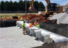
We provide comprehensive civil engineering solutions including site development, drainage systems, and roadway design. Our engineers create practical plans that meet regulatory requirements while optimizing project efficiency. Services support commercial developments, municipal projects, and private landowners across the southeastern United States.
Construction Surveys
Our construction survey services ensure accurate implementation of engineering plans through precise layout and elevation control. We support contractors with boundary verification, utility location, and as-built documentation throughout project phases. This maintains compliance with design specifications and local regulations.
Aerial Mapping
We utilize drone technology for high-resolution aerial mapping and photogrammetry. This service provides detailed site analysis, progress monitoring, and volumetric calculations for large-scale projects. Our FAA-certified pilots capture data efficiently while maintaining survey-grade accuracy for engineering applications.
Subdivision Plats
Our team prepares subdivision plats for residential and commercial developments, including lot layout, easement design, and regulatory compliance. We coordinate with local jurisdictions to ensure proper approvals and create legally recorded documents that facilitate property transactions and development.
People
Jeremy McMath
Owner / Professional Engineer
As founder and licensed Professional Engineer, Jeremy leads with faith-driven leadership and 15+ years of civil engineering experience. He focuses on client relationships and technical excellence while maintaining the company's core values of service and integrity.
Chase Cotton
Co-Founder
Chase, one of the original co-founders, brings extensive infrastructure design expertise. With experience in municipal projects and private development, he contributes technical knowledge and strategic guidance to maintain engineering standards across all projects.
Tindell Adams
Professional Land Surveyor
As a licensed Professional Land Surveyor, Tindell oversees all surveying operations with 12 years of experience in boundary determination and ALTA surveys. He ensures legal compliance and precision in property documentation for commercial and residential clients.
Lane Chatham
Project Engineer
Lane manages civil engineering projects with expertise in site development and drainage design. He coordinates technical teams to deliver practical solutions that balance client needs with regulatory requirements for public and private sector clients.
Jenny Searcy
Project Manager
Jenny coordinates multi-disciplinary projects with 8 years of experience in engineering project management. She ensures timely delivery of services while maintaining quality standards across civil design and surveying assignments.
Questions
What areas do you serve?
We provide services throughout Alabama and Northwest Florida, with teams operating in multiple regional locations.
What surveying standards do you follow?
Our ALTA/NSPS land title surveys meet national standards for commercial property transactions and lending requirements.
Are your engineers licensed?
Yes, our team includes Professional Engineers (PE) and Professional Land Surveyors (PLS) licensed in multiple southeastern states.
What project types do you handle?
We work on residential subdivisions, commercial developments, municipal infrastructure, and industrial sites across public and private sectors.
How do you ensure project accuracy?
We use modern surveying equipment and software combined with licensed professionals' expertise to maintain precision throughout all project phases.