
Business Details
Your Trusted Land Surveying Partner on the Central Coast
Hannig Surveying is a land surveying firm dedicated to delivering highly accurate and precise surveys that empower stakeholders to make informed decisions and develop optimal projects. Our team utilizes modern, efficient equipment including Leica total stations, GPS systems, 3D scanners, and unmanned aerial vehicles (drones) to gather and validate field data. We employ the latest software to process point clouds and create conventional drawings, ensuring comprehensive and reliable results. The firm's principal, Steven C. Hannig, holds a bachelor's degree in Geography from San Francisco State University and is a licensed land surveyor in California with over two decades of experience in land development. His diverse background spans roles such as Project Manager for telecommunication and civil engineering projects, Civil Engineering Planner/Designer, and Survey Party Chief, providing a deep understanding of complex projects.Our commitment to precision and modern technology ensures clients receive actionable data tailored to their specific needs. We specialize in aerial mapping, topographic surveys, as-built surveys, ALTA site surveys, construction surveys, layout/staking, and monitoring services. Our work spans commercial, residential, and infrastructure projects across the Central Coast of California, including notable projects like the Hunters Point Naval Shipyard and Santa Maria Airport. With FAA-licensed drone operations and a focus on innovation, we deliver solutions that meet the highest industry standards. Our clients benefit from our technical expertise, local knowledge, and dedication to excellence in every surveying task.

Services
Aerial Mapping
Topographic Surveys
As-Built Surveys
ALTA Site Surveys
Construction Surveys
Layout/Staking
Monitoring
3D Scanning
Volumetric Surveys
Ortho Photos
Highlights and features
- We offer over two decades of land development expertise.
- Our team uses advanced drones and 3D scanning technology.
- We provide comprehensive surveying solutions for all project types.
- Our local knowledge ensures tailored, accurate results.
- We hold FAA certification for drone operations.
Associations and certifications
- FAA Licensed UAV Pilot
- California Licensed Land Surveyor
Services
Aerial Mapping
Our aerial mapping services utilize FAA-licensed drones to capture high-resolution ortho photos and topographic data. This technology enables efficient, large-scale surveys for infrastructure and land development projects. Clients receive precise, actionable data to support planning and construction decisions.
Topographic Surveys
We conduct detailed topographic surveys to map natural and man-made features, including elevation changes and water lines. These surveys are critical for engineering, construction, and environmental planning. Our use of 3D scanners and GPS ensures unmatched accuracy for project feasibility studies.
Construction Surveys
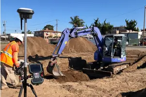
Our construction surveys provide precise layout and staking for new developments, ensuring alignment with design plans. We support projects from initial groundwork to final inspections. Clients benefit from reduced errors and streamlined project timelines through our monitoring services.
3D Scanning
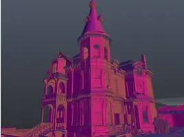
We use advanced 3D scanning to create detailed digital models of structures and landscapes. This technology is ideal for historical preservation, structural analysis, and as-built documentation. Our scans deliver millimeter-level precision for accurate design and restoration work.
ALTA Surveys
Our ALTA surveys meet national standards for commercial property transactions, identifying boundaries, easements, and improvements. These surveys are essential for title insurance and legal compliance. Clients receive comprehensive reports to mitigate risks in real estate deals.
People
Steven C. Hannig
Principal Surveyor
Steven holds a geography degree from San Francisco State University, is a licensed California land surveyor, and FAA-licensed drone pilot with over 20 years in land development and surveying.
Questions
What services does Hannig Surveying offer?
We specialize in aerial mapping, topographic surveys, as-built surveys, ALTA site surveys, construction surveys, layout/staking, monitoring, and 3D scanning for commercial and residential projects.
How does Hannig Surveying use drone technology?
We employ FAA-licensed drone operations to gather precise field data, enabling efficient aerial mapping and topographic surveys with high accuracy.
What areas does Hannig Surveying serve?
We operate across California's Central Coast, including San Luis Obispo, Santa Maria, Paso Robles, and surrounding regions.
What makes Hannig Surveying's team qualified?
Our principal holds a geography degree, is a licensed California land surveyor, and has over 20 years of experience in land development and surveying.
Can Hannig Surveying handle complex projects?
Yes, our diverse background in civil engineering and surveying ensures expertise in managing even the most complex projects.
What industries benefit from your services?
We support infrastructure, residential, commercial, and historical preservation projects, including work at airports, railroads, and urban developments.
Videos