Empowering Your Vision, One Project at a Time.
RP & Associates Land Surveying and Drafting, LLC is a multi-disciplinary firm dedicated to providing comprehensive surveying, drafting, and UAS mapping services to the Charleston area. We are driven by a commitment to excellence and a passion for delivering projects that exceed expectations. Our team of highly motivated and professional surveyors, drafters, and technicians leverages cutting-edge technology to ensure precise, accurate, and timely results.
Founded on the principle that every project is unique, we understand the importance of personalized attention and tailored solutions. We take the time to understand our clients' needs, goals, and challenges, working collaboratively to develop innovative and cost-effective strategies. With a deep understanding of the intricacies involved in land surveying, drafting, and UAS mapping, we strive to be a trusted partner throughout every stage of your project.
Our Services: A Comprehensive Approach
At RP & Associates, we provide a comprehensive suite of services designed to support a wide range of projects, from residential and commercial developments to complex infrastructure projects. Our service offerings encompass:
- Construction Surveying: We specialize in providing construction stakeout, erosion control, and as-built surveys for a variety of building projects. Our detailed and precise surveys ensure that construction projects are completed according to plan, minimizing costly delays and rework.
- UAS/Drone Mapping: Leveraging the latest drone technology, we offer aerial mapping and surveying services, capturing high-resolution imagery and data for a comprehensive understanding of your site. This technology allows for efficient data collection, providing enhanced accuracy and detail for various project applications, such as topographic surveys, volumetric calculations, and infrastructure inspections.
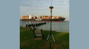
- Land Surveying: Our experienced surveyors conduct a wide range of land boundary, topographic, and easement surveys to provide reliable and accurate legal descriptions, property lines, and elevation information. We also specialize in hydrographic surveying, which involves mapping submerged land and water bodies.
- Drafting & BIM Modeling: We combine traditional drafting skills with advanced Building Information Modeling (BIM) software to create detailed 2D and 3D models of buildings, infrastructure, and other projects. BIM models provide a valuable tool for visualization, coordination, and cost estimation throughout the project lifecycle.
- Other Specialized Services: We offer a comprehensive range of specialized surveying services, including elevation certificates, wetland delineations, infrastructure modeling, and volume calculations. Our expertise in these areas enables us to provide customized solutions tailored to the specific needs of our clients.
Technology & Innovation
At RP & Associates, we are committed to staying at the forefront of surveying and drafting technology. We continuously invest in cutting-edge equipment and software to ensure that our services are efficient, reliable, and consistently deliver the highest level of accuracy. From 3D laser scanning and GPS equipment to advanced BIM software, we leverage the latest advancements to optimize our processes and provide our clients with exceptional results.
Commitment to Excellence
Our success is driven by our unwavering commitment to excellence. We strive for precision, accuracy, and integrity in all aspects of our work. We believe that clear communication, effective collaboration, and a customer-centric approach are essential to building strong relationships with our clients and delivering projects that exceed expectations.
We are dedicated to being a reliable partner for all your land surveying and drafting needs.

Be the first to review R P & Associates Land Surveying.
Write a Review