
Business Details
33 Years
experience
Accurate Land Surveying Services in Monterey
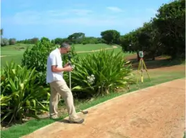
Since 1993, Central Coast Surveyors has been a key player in delivering professional surveying and mapping services throughout the Monterey Bay area. Our dedicated team combines over 35 years of experience with state-of-the-art technology to handle projects of all sizes, from small residential topographic maps to high-rise hotels and major retail centers. We specialize in a comprehensive range of services including topographic surveys, boundary surveys, ALTA/NSPS Land Title Surveys, construction staking, GPS surveys, and FEMA Elevation Certificates. Our commitment to precision and timely delivery ensures that each project meets the highest standards of quality.Licensed in both California and Hawaii, we serve diverse industries such as engineering, architecture, environment, telecommunications, real estate, and public agencies. Our ability to communicate effectively and address client needs quickly has made us a trusted choice for land surveying in Monterey County. With fast turnaround times and a focus on client satisfaction, we continue to provide exceptional value to our customers across the Greater Monterey Bay Area.
Services
Topographic Surveys
Construction Surveys
ALTA/NSPS Land Title Surveys
Boundary Surveys
FEMA Elevation Certificates
GPS Surveys
Photogrammetric Control Surveys
Expert Witness Services
Details
- Year established: 1993
Highlights and features
- We provide fast and accurate surveying with over 35 years of local experience
- Our field crews include licensed land surveyors on every project
- We use modern surveying instruments and CAD software for high-quality results
- We offer quick turnaround times with service usually within 24 hours notice
- We serve diverse industries including engineering, architecture, and real estate
Services
Topographic Surveys
Our topographic surveys create detailed maps showing land contours, elevations, and natural/man-made features. Using modern instruments and CAD software, we deliver precise data for construction and development projects. Architects and engineers rely on our topographic maps for accurate planning and design in the Monterey Bay area.
ALTA/NSPS Surveys
We conduct ALTA/NSPS Land Title Surveys following strict standards for commercial properties. These surveys identify boundaries, easements, encroachments and utility locations. Our detailed maps meet lender requirements for property transactions and refinancing across the Greater Monterey Bay Area.
Construction Staking
Our construction staking services provide precise reference points for building projects. With licensed surveyors on every crew, we analyze design data and deliver clear staking diagrams. Clients receive fast, accurate field services typically within 24 hours notice in Monterey County.
Boundary Surveys
We determine property boundaries through meticulous record research and field measurements. Our boundary surveys help with land transactions, fencing, and resolving property disputes. Clients receive documented corner records and legal descriptions based on California surveying regulations.
FEMA Certificates
We provide FEMA Elevation Certificates to assess flood risk for insurance purposes. Our surveys determine if properties fall in floodplains and establish proper elevation data. This information helps clients understand flood insurance requirements for properties in the Monterey and Carmel Valley regions.
Questions
What surveying services do you offer in Monterey County?
We provide topographic surveys, ALTA/NSPS Land Title Surveys, boundary surveys, construction staking, GPS surveys, and FEMA Elevation Certificates for residential and commercial clients throughout Monterey County.
How long has Central Coast Surveyors been in business?
Central Coast Surveyors has been providing land surveying services since 1993, with over 35 years of combined experience from our professional team members.
Do you serve areas beyond Monterey?
Yes, while based in Monterey, we also serve Hollister, Santa Cruz, and the entire Greater Monterey Bay Area with our surveying and mapping services.
What makes your surveying services different from others?
We combine state-of-the-art technology with experienced licensed surveyors on every project, delivering fast turnaround times and accurate results that meet strict professional standards.
Are your surveyors licensed in California?
Yes, we're licensed in California with license #LS4974 and Hawaii with license #LS11860, ensuring our surveying work meets all regulatory requirements and industry standards.
How quickly can you complete a survey project?
We typically provide construction staking services with less than 24 hours notice and deliver fast, accurate results while maintaining the highest quality standards for all survey types.