Business Details
24 Years
experience
Your Trusted Civil Engineering Partner in Broomfield, CO
Wohnrade Civil Engineers is a Colorado-based civil engineering consulting firm that implements a relationship-based business model, collaborating closely with clients to identify and resolve potential issues throughout project lifecycles. Our team of engineers brings over 100 years of combined experience, delivering meticulous attention to detail that reduces changes during design and construction phases. We specialize in site development, roadway design, floodplain analysis, and drone-assisted mapping, ensuring cost-effective solutions for residential, commercial, industrial, and municipal projects. Our expertise in regulatory compliance and environmental challenges streamlines project approvals while minimizing timelines.With FAA-certified drone operators and engineering-grade deliverables since 2015, we integrate cutting-edge technology to enhance data accuracy and workflow efficiency. Our commitment to enduring client relationships has resulted in successful project completions across multiple states, supported by a proven track record of 300+ engineering projects and 100+ annual flight hours. We prioritize transparency, reliability, and technical excellence, evidenced by five industry awards and testimonials from long-term clients spanning 15 years. Our services include drinking water systems, stormwater engineering, wastewater management, and metro district cost certifications, all backed by a safety-focused operational philosophy.

Services
Civil Engineering
Drone Surveying
Floodplain Analysis
Roadway Design
Stormwater Management
Wastewater Engineering
GIS Mapping
Site Development
Metro District Certifications
UAS Data Collection
Details
- Year established: 2002
Highlights and features
- We have over 100 years of combined engineering experience.
- Our FAA-certified drone operators deliver engineering-grade mapping data.
- We implement patented drone technologies for high-accuracy deliverables.
- Our team provides 24/7 project consultation and support.
- We guarantee cost reductions through optimized design workflows.
Associations and certifications
- FAA Part 107 Certified
What people say
Consistency and reliability
Cost-effective solutions
Expertise in civil engineering
Safety-focused operations
High-accuracy drone data
Services
Civil Engineering
Our civil engineering services provide end-to-end solutions for site development, regulatory compliance, and infrastructure projects. With expertise in roadway design, floodplain analysis, and municipal systems, we deliver cost-effective, code-compliant designs. Our engineers prioritize efficiency and accuracy, reducing project costs through meticulous planning and integration of drone-assisted data.
Drone Surveying
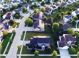
Drone surveying services capture high-resolution topographic data using FAA-certified operators and advanced LiDAR technology. We produce engineering-grade deliverables compatible with CAD/GIS software, enabling precise site analysis and reducing fieldwork time. Our 100+ annual flight hours ensure rapid data collection for complex projects across Colorado and surrounding states.
Floodplain Analysis
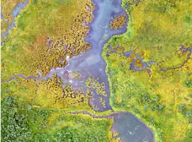
Floodplain analysis services include FEMA map revisions, risk assessments, and mitigation strategies. We specialize in securing No Rise Certifications and reducing flood insurance premiums through accurate modeling. Our engineers have successfully completed FEMA revisions for entire subdivisions, leveraging drone LiDAR data to enhance precision and regulatory compliance.
Roadway Design
Roadway design services cover local roads, highways, and bike trails with expertise in traffic management and utility coordination. We deliver solutions that balance safety, regulatory requirements, and budget constraints. Our team's experience includes roundabouts, railroad crossings, and rehabilitation projects, ensuring durable, efficient transportation infrastructure.
Stormwater Engineering
Stormwater engineering services include detention basin design, erosion control, and watershed planning. We develop systems to manage extreme flood conditions and ongoing drainage needs, integrating hydrological modeling with site-specific challenges. Our solutions comply with environmental regulations while minimizing long-term maintenance costs for urban and rural communities.
People
Mary Wohnrade
Owner
Mary Wohnrade, P.E., leads Wohnrade Civil Engineers with over 20 years of experience in civil engineering and drone technology integration. She has spearheaded high-profile UAS projects since 2015, collaborating with industry leaders to develop innovative solutions. Her expertise in regulatory compliance and project management ensures client success across complex engineering challenges.
Anne Best Johnson
Land Manager
Anne Best Johnson has partnered with WCE for 15 years, relying on their expertise in residential, commercial, and environmental projects. She highlights their ability to deliver consistent, reliable solutions that save time and reduce costs through alternative design approaches.
Stacy W. Hebb
FAA Representative
Stacy W. Hebb, representing the FAA, has observed WCE's drone operations firsthand. He praises their safety protocols and operational excellence, noting their staff's professionalism and the impressive efficiency of their mapping drones in complex environments.
Questions
What civil engineering services do you offer?
We provide site development, roadway design, floodplain analysis, stormwater engineering, wastewater systems, and drone-assisted mapping services for residential, commercial, and municipal projects.
How does drone technology benefit my project?
Our FAA-certified drone operations capture high-resolution data 70% faster than traditional methods, reducing survey costs and enabling precise engineering-grade deliverables compatible with CAD/GIS software.
Can you help with FEMA flood map revisions?
Yes, we specialize in FEMA LOMR/CLOMR submissions and have secured flood insurance premium reductions for entire subdivisions using drone LiDAR mapping and hydrological modeling.
What areas do you serve?
While based in Colorado, we complete projects across multiple states, with drone surveying capabilities extending to remote locations requiring high-accuracy topographic data.
How do you ensure project compliance?
Our engineers combine regulatory expertise with drone data verification to ensure all projects meet federal, state, and local requirements while minimizing approval timelines.