Business Details
32 Years
experience
Precision Land Surveying Services in Wisconsin
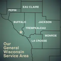
Burt Surveying was founded in 1994 by Daniel J. Burt, who identified a need for reliable surveying services in West Central Wisconsin. Starting with limited resources from a small office, our company has grown into a trusted provider while maintaining its family-owned roots. Following Dan's untimely passing in 2006, his wife Brenda assumed leadership with a dedicated team managing daily operations. Today, we continue Dan's commitment to quality, affordability, and community service. With over 30 combined years of experience, we specialize in precise land, elevation, and site planning surveys using modern GPS technology.Our team includes licensed professionals in Wisconsin and Minnesota, and we remain proud members of the Wisconsin Society of Land Surveyors. We serve Buffalo, Trempealeau, and adjoining counties, delivering personalized attention that larger firms cannot match. Our reputation for accuracy and client-focused service has resulted in consistent growth through referrals and word-of-mouth. We remain committed to providing fair pricing while maintaining the highest standards of professional integrity and technical excellence.
Services
Land Surveying
Elevation Surveying
ALTA Surveys
GPS Mapping
Subdivision Services
Site Planning
LOMA Surveys
Construction Staking
Topographic Surveys
Property Re-surveying
Details
- Year established: 1994
Highlights and features
- Licensed surveyors with over 30 years of combined experience in Wisconsin and Minnesota
- Specialize in removing flood insurance requirements through certified LOMA surveys
- Maintain precise records of all surveys filed with county officials
- Utilize modern GPS technology for efficient and accurate measurements
- Family-owned business with a strong community reputation since 1994
Associations and certifications
- Wisconsin Society of Land Surveyors
What people say
Prompt and in communication
Great job on the survey
Well done job
Good service
Excellent job
Services
Land Surveying
Burt Surveying provides comprehensive land boundary determination services using modern GPS technology. Our certified professionals accurately establish property lines, resolve boundary disputes, and create detailed legal descriptions. We follow strict state standards while maintaining personal client communication throughout the process.
Elevation Surveying
Our elevation surveying services precisely measure land contours and building elevations. This critical data helps property owners eliminate unnecessary flood insurance costs through FEMA Letter of Map Amendments while ensuring compliance with local zoning regulations and development requirements.
ALTA Surveys
We conduct comprehensive ALTA/ACSM surveys that meet national standards for property boundary verification. These detailed surveys identify easements, encroachments, and right-of-way issues while providing title companies and lenders with the information needed to issue title insurance policies.
GPS Mapping
Our GPS technology enables efficient and accurate property mapping with reduced field time. This advanced system maintains consistent precision across large properties without compounding measurement errors, providing clients cost savings and improved data reliability.
Site Planning
We support construction and development projects with precise site planning surveys. Our team creates detailed topographic maps, establishes grading plans, and provides construction staking services that guide development while maintaining legal compliance and boundary integrity.
People
Brandon King
Professional Land Surveyor
Licensed in both Wisconsin and Minnesota, Brandon brings technical expertise and state-specific knowledge to every surveying project he manages.
Chase Melstrom
Survey Technician
Chase supports survey crews with field data collection and equipment operation, applying his technical training to ensure measurement accuracy.
Mark Burt
Survey Technician
Following in his father's footsteps, Mark combines family tradition with modern surveying methods as a key member of our field team.
Questions
How is land survey cost determined?
Survey costs depend on terrain complexity, property size, required research, existing markers, and seasonal accessibility factors.
Can flood insurance requirements be removed?
We can help remove flood insurance requirements through FEMA Letter of Map Amendments using precise elevation data.
What markers do you use for property boundaries?
We use 3/4 x 18 iron rebar with wood lath flagging for corners, and wood lath markers at 100-150 foot intervals for lines.
How long does a survey take?
Fieldwork typically takes 1-2 business days, with map preparation completed within 1-2 weeks depending on complexity.
Do you work in winter conditions?
We conduct surveys year-round, with woodland surveys recommended between late fall to early spring for optimal accuracy.
Are surveys filed with public records?
All standard surveys are recorded with county surveyors or register of deeds offices for permanent documentation.