Business Details
44 Years
experience
Professional Land Surveying Services in Abilene, TX
Founded in 1982 by Maxey Sheppard, a Registered Professional Land Surveyor and Licensed State Land Surveyor, our company has dedicated over four decades to delivering precise and reliable land surveying services across Texas. We combine cutting-edge technology with traditional methods to ensure accuracy in boundary determination, route surveys, and engineering projects. Our team prioritizes thorough research, field verification, and client collaboration to produce defensible surveys that meet legal and technical standards.With expertise in oil and gas, wind energy, and FEMA flood elevation projects, we maintain active involvement in professional associations to stay at the forefront of industry advancements. Our commitment to quality is reflected in our meticulous process, from courthouse record analysis to final plat preparation, ensuring client satisfaction and long-term project integrity.
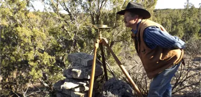
Services
Boundary Surveys
Route Surveys
Control Surveys
Oil & Gas Locations
Wind Energy Surveys
FEMA Flood Data
TxDOT Surveys
ALTA Surveys
Preliminary Engineering
Land Partitioning
Details
- Year established: 1982
Highlights and features
- We have over 40 years of experience in Texas land surveying since 1982
- Our team uses advanced GPS and CAD technology with traditional methods
- We provide detailed quotes after thorough project requirement analysis
- Our surveys include comprehensive courthouse research and field verification
- We maintain active membership in professional surveying associations
Associations and certifications
- Registered Professional Land Surveyor (RPLS)
- Licensed State Land Surveyor (LSLS)
Services
Boundary Surveys
Our boundary surveys determine property lines using legal records, GPS technology, and traditional field methods. We research courthouse archives, locate physical monuments, and prepare legally defensible plats for real estate transactions, partitions, and dispute resolution. The process includes mathematical verification and official certification by Registered Professional Land Surveyors.
Route Surveys
We conduct route surveys for pipelines, power lines, and transportation corridors. Our team establishes easement boundaries, prepares topographic maps, and provides staking for construction alignment. Projects include multi-county petroleum pipelines and Foard County power transmission lines, ensuring compliance with regulatory requirements and engineering specifications.
Control Surveys
Our control surveys establish precise horizontal and vertical reference points for large-scale projects. This includes monitoring control networks for detention ponds, highway projects, and airport developments. We use advanced GPS systems and traditional methods to maintain accuracy across long-term infrastructure projects requiring millimeter-level precision.
Oil & Gas Locations
We provide surveying services for oil and gas operations including well staking, unit boundary determination, and pipeline routing. Our team works with geologists to locate abandoned wells, prepare plat maps, and ensure compliance with Texas Railroad Commission requirements. Services include both conventional and digital data collection methods.
Wind Energy Surveys
Our wind energy surveys include boundary verification, topographic mapping, and construction staking for wind farms. We provide ALTA-certified surveys ensuring project boundaries align with title documents, supporting financing and insurance requirements for large-scale renewable energy developments across Texas.
People
Maxey Sheppard
President & Founder
Registered Professional Land Surveyor with 40+ years experience in Texas boundary law. Developed industry training programs and served as Texas Society of Professional Surveyors President. Specializes in complex boundary disputes and legal survey testimony.
Monte Sheppard
Party Chief
Field operations manager with 20+ years experience. Certified Level II Survey Technician with expertise in GPS systems, AutoCAD, and boundary retracement. Former military medic and Texas EMT with specialized training in high-precision survey equipment.
Questions
Why do I need a boundary survey?
A boundary survey confirms property lines through legal research and field measurements, preventing disputes during real estate transactions or partitions.
What services do you offer?
We provide boundary surveys, route surveys, control surveys, oil & gas locations, wind energy projects, and ALTA-certified surveys across Texas.
How are survey costs determined?
Costs depend on property size, location, required research, and project complexity. We provide detailed quotes after reviewing your specific requirements.
Are your surveyors licensed?
Yes, our team includes Registered Professional Land Surveyors and Licensed State Land Surveyors certified by the Texas Board of Professional Land Surveying.
Do you work on large infrastructure projects?
Yes, we handle TxDOT highway projects, multi-county pipelines, and wind farms requiring precise control surveys and ALTA certifications.